 Iconic Global Iconic Global is a global media company, focusing on business, investing, technology, entrepreneurship, leadership, and lifestyle.

Related Articles


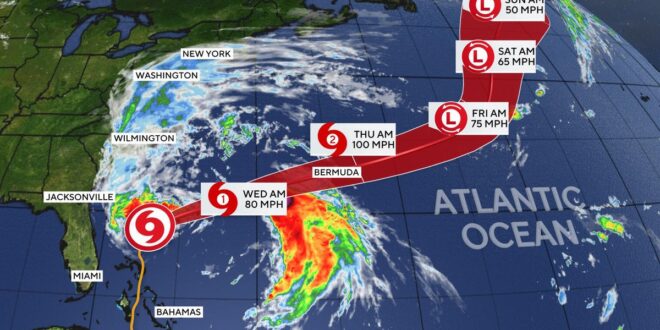
Hurricane Imelda reached Bermuda Wednesday night as a Category 2 storm, pounding the archipelango with heavy rain and powerful winds before weakening and continuing on its path out into the Atlantic, according to the Miami-based National Hurricane Center.
Imelda is the ninth named storm of the 2025 Atlantic hurricane season. It formed on Sunday in the western Atlantic and strengthened into a hurricane early Tuesday.
Hurricane Imelda forecast maps
As of 2 a.m. ET on Thursday, Imelda’s center was located about 80 miles east-northeast of Bermuda, with maximum sustained winds of 90 mph, according to the hurricane center, indicating that it had weakened to a Category 1 storm. Imelda was moving east-northeast at 30mph.
Imelda’s core was forecast to move further away from Bermuda over the course of Thursday morning, the hurricane center said.
The storm is expected to weaken further to an extratropical low-pressure cyclone sometime Thursday.
CBS News
The NHC said hurricane-force winds were recorded on Bermuda, but there were no immediate reports of damage from the gusts or heavy rainfall that had been expected to bring possible flash flooding and damaging waves.
Anywhere from 2 to 4 inches of rain had been expected across Bermuda into Thursday.
Swells generated by Imelda and Hurricane Humberto, farther out in the Atlantic, were also spreading to much of the U.S. East Coast. “These swells are likely to cause life-threatening surf and rip current conditions,” forecasters said.
A hurricane warning remained in effect for Bermuda early Thursday morning, meaning hurricane conditions were still expected.
CBS News 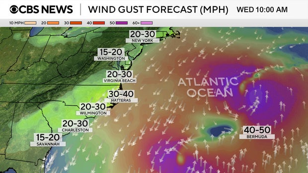
Imelda follows Hurricane Humberto
Imelda comes on the heels of Humberto, which rapidly intensified to a major hurricane over the Atlantic on Saturday but is not expected to reach land. Humberto reached as high as a Category 5 on Saturday before beginning to weaken. On Wednesday morning, the sustained winds for Humberto’s remnants fell to 70 mph, below the 74 mph threshold for a Category 1 hurricane.
NOAA / National Hurricane Center 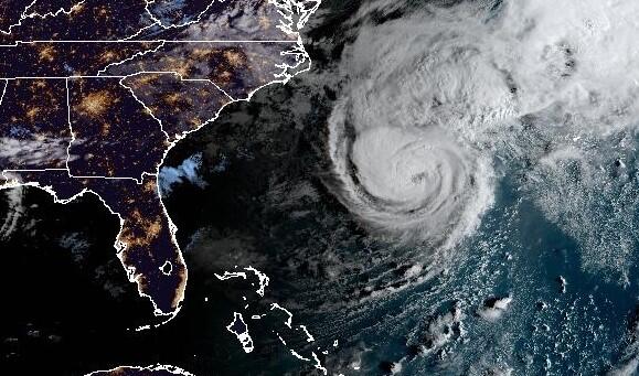
Forecasters said last week there was a small possibility the two systems could interact, creating what is known as a Fujiwhara effect, a rare phenomenon in which two different storms merge and become entangled around a newly formed, common center. CBS News meteorologist Nikki Nolan said that wasn’t considered a likely outcome in this case, although it wasn’t impossible, and the two storms already affected each other because of their close proximity at one point over the Atlantic.
CBS News 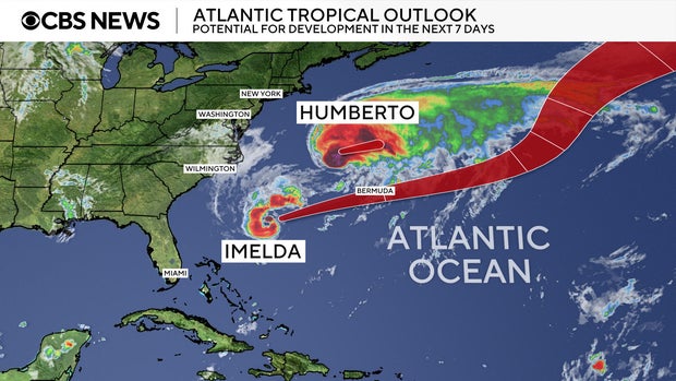
contributed to this report.